
martes, 20 de diciembre de 2016
jueves, 15 de diciembre de 2016
La hidrografía en España
Tema 3 La Hidrografía de España
La hidrografía es el estudio geográfico del agua de la Tierra. Los ríos son
cuerpos de agua naturales que comienzan en regiones montañosas, cruzan los
paisajes y fluyen hacia el mar, lagos u otros ríos (afluentes afluentes).
Los elementos de un río son: Nacimiento (donde el agua emerge para
convertirse en un río), la desembocadura (donde termina el río) y el canal o curso
(donde fluye el agua). Hay tres partes en un río:
- Curso alto: En zonas montañosas donde se produce una fuerte erosión.
- Curso medio: En la sección central, forman afluentes y valles, se produce también una fuerte erosión y sedimentación.
- Curso bajo: la desembocadura del río, forma deltas.
Los ríos tienen algunas características y dependen del relieve y el clima:
- Longitud: La distancia.del río
- Caudal: La cantidad de agua que pasa por el río.
- Régimen: La variación de la caudal a lo largo del año
En España hay tres cuencas o vertientes:
- La vertiente Cantábrica: ríos cortos, procedentes de la Cordillera
Cantábrica. Corriente fuerte todo el año. Buen lugar para construir embalses. Los
principales ríos son: Eo, Navía Nalón, Besaya, Nervión y Bidasoa.
- La vertiente Atlántica: Ríos que atraviesan la Meseta y la Depresión del
Guadalquivir (ríos largos y voluminosos con régimen variable). Los principales
ríos son Miño, Duero, Tajo, Guadiana y Guadalquivir.
- La vertiente mediterránea: Suelen ser ríos cortos excepto el Ebro, regímenes variables, en
algunos casos desaparecen en verano. Los principales ríos del este son: Ter,
Llobregat, Ebro, Turia, Segura, Jucar. Los principales ríos del sur son:
Almanzora y Guadalhorce.
El paisaje particular y el clima en Islas baleares y canarios impiden la
formación de ríos permanentes. Cuando llueve se forman torrentes en las Islas
Baleares y cañadas (cascadas - cataratas) en las Islas Canarias ..
Lesson 3 The Hydrography of Spain
Lesson 3 The Hydrography of Spain
Hydrography is the geographical study of the water of the Earth. Rivers
are natural, flowing bodies of water that start in mountainous regions, cross
the landscapes and flow into the sea, lakes or other rivers (tributaries = afluentes).
The elements of a river are: The source (where the water emerges to
become a river), the mouth (where the river ends) and the channel or course
(where the water flows). There are three parts in a river:
-
Upper course: In mountainous areas, heavy erosion.
-
Middle course: In the central section, form
tributaries and valleys, heavy erosion and sedimentation.
-
Lower course: the mouth of the river, forms deltas.
Rivers have some
characteristics and depend on the relief and climate:
-
Length: The distance.
-
Discharge: The amount of water passing through the
river.
-
Regime: The discharge variation throughout the year
In Spain there are three basins:
-
The Cantabrian Basin: short rivers, come from the
Cantabrian Range. Strong current all the year. Good place to build reservoirs.
The main rivers are: Eo, Navía Nalón, Besaya Nervión y Bidasoa.
-
The Atlantic Basin: Rivers run through the Meseta and
the Guadalquivir Depression (long and voluminous rivers with variable regime).
The main rivers are Miño, Duero, Tajo, Guadiana and Guadalquivir.
-
The Mediterranean Basin: Shorts except the Ebro,
variable regimes, in some cases disappear in summer. The main rivers of the
east are: Ter, Llobregat, Ebro, Turia, Segura, Jucar. The main rivers in south
are: Almanzora and Guadalhorce.
The particular
landscape and climate in the Balearic and Canary Islans prevent the formation
of permanent rivers. When it rains torrents are formed in Balearic Islands and
ravines (cascadas - cataratas) in the Canary Islands.
martes, 13 de diciembre de 2016
Vocabulary Unit 3
VOCABULARIO DE LA UNIDAD 3


DRIVE
https://drive.google.com/open?id=0B-ZkKniJO6OccUNUTlprbDJJcWM

DRIVE
https://drive.google.com/open?id=0B-ZkKniJO6OccUNUTlprbDJJcWM
lunes, 28 de noviembre de 2016

viernes, 18 de noviembre de 2016
Examen de prueba Tema 1 Social Science
Los alumnos de 6ºB han elaborado este control con el que podremos repasar el Tema 1 de Social Science de cara a la prueba final de sexto de este curso.
1.
Localiza en el mapa : Pirineos, Cordillera Costero Catalana , Portugal ,Sistema Central, Almanzor, Montes Vascos, Aneto
2.
Dime los picos mas altos de España
3.¿Qué es la meseta?
4.
Dime la definición de :
Valle:
Pico:
5.¿Cuáles
son los bordes de la meseta?
6. Hay alguna depresión en el mapa, di cuáles son y localízalos/as
7. ¿Qué es es una depresión?
Respuestas:
2. Aneto, Almanzor, Mulhacén, Teide
3. Es una llanura elevada respecto al nivel del
mar
4. Valle: es una llanura de montañas o alturas de
una depresión
Pico : la cima de la
montaña o la parte más alta de la montaña
5. Montes de León en la
parte norte de la meseta
6. Si están la depresión
del Ebro y la de el Guadalquivir
7. Una depresión es un área baja plana por debajo del nivel del mar.
miércoles, 2 de noviembre de 2016
Vocabulario Unidad 2 en Power point
Aquí está el enlace de Google Drive que da acceso al vocabulario del tema 2. También pueden usar el código qr para acceder con móviles o tablets que han elaborado los propios alumnos. Esperamos que lo disfruten y lo usen.

https://drive.google.com/open?id=0B-ZkKniJO6OcMW50ZFhSVXNhTHc
viernes, 28 de octubre de 2016
Rúbrica Unidad 2
En este post hemos adjuntado la rúbrica de la Unidad 2.
Una rúbrica es una herramienta de evaluación que permite al alumno saber de qué y cómo se le va a evaluar en cada momento sabiendo qué puntuación van a obtener en cada momento teniendo en cuenta su trabajo, desarrollo etc. Gracias a ella los alumnos saben perfectamente qué potenciar con el objetivo de mejorar y avanzar en todo momento.

Una rúbrica es una herramienta de evaluación que permite al alumno saber de qué y cómo se le va a evaluar en cada momento sabiendo qué puntuación van a obtener en cada momento teniendo en cuenta su trabajo, desarrollo etc. Gracias a ella los alumnos saben perfectamente qué potenciar con el objetivo de mejorar y avanzar en todo momento.

lunes, 24 de octubre de 2016
Lesson 2 Coastal landforms in Spain
Lesson 2 Coastal landforms in Spain
The Spanish
coastline
The Spanish
coastline is about 7800 km long and it is divided into peninsular
coast, Balearic and Canary Islands and Ceuta and Melilla and are surrounded
by the Atlantic Ocean, Cantabrian Sea and the Mediterranean Sea.
Spanish
coast are made of cliffed
and rocky coasts and plains with beaches. The coasts are determined by various
factors:
- The
land Relief: Mountain ranges form cliffed and rocky shorelines and plains near
the coast form beaches.
- The
tides: cause sand
and marine deposits and form beaches.
- Coastal
Erosion: Is the breaking down of land near coasts.
The spanish
coastlines
There are five different coastlines:
- Atlantic
coast of Cantabria:
In the north between Francia and Cabo Ortegal.
- Atlantic
coast of Galicia: northwest
between Cabo Ortegal y Portugal.
- Atlantic
coast of Andalucía:
southwest between Portugal and the Estrecho de Gibraltar.
- Mediterranean
coast of Andalucía:
In the Southeast between Estrecho de Gibraltar and Murcia.
- The
Eastern Mediterranean Coast:
From Murcia to Francia:
- Canary
Islands are surrounded by the Atlantic Ocean and Ceuta, Melilla and Balearic
Islands are surrounded by the Mediterranean Sea
The Atlantic
Coastline
The
Atlantic coast of Cantabria: formed
by high rocky cliffs. There are rías and sandy beaches. This
coast is bordered by the Cantabrian Sea which connects to the Atlantic Oceans. Its
waters are cold with strong waves. Notable landforms of this coast are: Estaca
de Bares, Cabo de Peñas, Cabo de Ajo y Cabo de Machichaco. Ría
de Nervión Bidasoa and the Bahía de Santander.
The
Atlantic Coast of Galicia: Irregular coast formed by rocky cliffs. It has got
deeper rías than the
rías we find in Cantabria. There are two kind of
rías Altas (al norte del cabo Finisterre) and Bajas (al sur del cabo
Finisterre).
Notable
landforms of this coast are: Cabo Ortegal, Cabo de Finisterre, Ría de Vigo, Ría
de Arousa y ría de Pontevedra.
The Atlantic coast of Andalucía: From the Guadiana River to the Estrecho de
Gibraltar (300 km). The coast is straight and sandy (it has dunes
too in Cadiz and Huelva) because it´s near the Guadalquivir depression the
lowest area of Spain. Notable landforms of this coast are:
Ría de Huelva, Golfo de Cadiz, Bahía de Cadiz, Cabo de Trafalgar y Punta de
Tarifa.
The Mediterranean
Coastline
Mediterranean
coast of Andalucía
From the Estrecho de Gibraltar to the border of
Andalucía and Murcia.
The coast is formed by cliffs because it´s near the cordillera Penibética.
Flatter zones can be found in Malaga. Notable landforms are the Golfo
de Almería y el Cabo de Gata.
The Eastern Mediterranean
coast
- The
East Coast: Its made up
of the coasts of Murcia, Com. Valenciana y el Delta
del Ebro. It
has small deltas, saltlakes, lagoons and sandy beaches. There are coastal
areas with rocky cliffs such as Cabo de la Nao. We canfound the Golfo
de Valencia too.
- The
Catalan Coast: From the Delta del Ebro to France. Rocky sea cliffs can be found
in la Costa Brava in Girona and some plains forming beaches. The most important
landforms are the Cabo de Creus and the Golfo de Rosas.
The Spanish
Archipielagos
There are two archipielagos:
- The
Balearic Islands: In
the Mediterranean sea and formed by five islands: Mallorca,
Menorca, Ibiza, Formentera y Cabrera. There are mountainous reliefs.
The highest peack is Puig Major in la sierra de Tramuntana. The coasts
are high and the mountains reach the sea (in Mallorca y Menorca) and sandy
beaches in Formentera.
- The
Canary Islands: In the Atlantic ocean. It´s formed by
seven islands: Tenerife, La Palma, Lanzarote, Fuerteventura, Santa Cruz, El
Hierro y Gran Canaria. They
are volcanic in origin (formed by molten rock or magma). The highest peack is Teide. The coast is
cliffed. We can find pebbles beaches on the western islands and sandy beaches
in Fuerteventura y Lanzarote.
lunes, 10 de octubre de 2016
Juega con los mapas
Hola Chicos y chicas de sexto. Aquí tenéis una página muy chula para que practiqueis con los mapas de España, Europa y el mundo.
Juegos de mapas
Juegos de mapas
miércoles, 5 de octubre de 2016
Apuntes Tema 1 (Español)
Los relieves de España
a) Principales caractrísticas geográficas de España
a) Principales caractrísticas geográficas de España
España está formada por la península ibérica, Canarias,
Baleares, Ceuta y Melilla. Limita al norte con Francia, Andorra y el Mar
Cantábrico, al oeste con Portugal y el océano Atlántico, al sur con África y al
este con el mar mediterráneo. Tanto las Islas Baleares como las Canarias son
archipiélagos. España tiene una gran altitud debido a la gran cantidad de
sistemas montañosos que tiene.
b) La Meseta
- Interiores de la Meseta
Los interiores de la meseta están en el centro de la
península , tienen una altitud media de 650 metros y cubre C. y León, C. la
Mancha, Madrid y Extremadura. Los ríos de la meseta desembocan en el Atlántico.
El Sistema Central se extiende por la península y Portugal y
divide la meseta en submeseta Norte y Sur. El Sistema central se divide en tres
sierras: Somosierra, Guadarrama y Gredos:
Los montes de Toledo separan el Valle del Tajo y del
Guadiana.
- Límites de la Meseta
Los límites de la Meseta serían: al noroeste los Montes de
León, al norte la Cordillera Cantábrica, al este el Sistema Ibérico (que
atraviesa, C, la Mancha, C. y León, Aragón y Valencia), que incluye los Picos
de Urbión y la Sierra de Albarracín y al sur Sierra Morena.
c) Sistemas montañosos del exterior de la Meseta
Los sistemas montañosos del exterior de la Meseta son: Macizo Galaico
(montañas de poca altura) Montes Vascos con varias alturas, Los Pirineos, que
miden más de 400 km extendiéndose por Navarra, Cataluña y Aragón y son la
frontera natural entre España y Francia y la Cordillera Costero Catalana
paralela al mar Mediterráneo. En el sur está el Sistema Bético dividido en
Sistema Penibético (más cerca del mar destacando Sierra Nevada y el Mulhacén) y
Subbético (en el interior destacando la Sierra de Cazorla).
d) Depresiones
Una depresión es una zona llana y hundida respecto a la zona que la rodea. En la península tenemos dos grandes depresiones:
- La depresión del Ebro: la más grande de las dos con 900 km de longitud, forma una llanura triangular y se extiende por La Rioja, Navarra, Aragón y Cataluña. El Delta del Ebro es la desembocadura del río y está formado por los materiales que arrastra el río a su paso.
- La depresión del Guadalquivir: Tiene una longitud de 600 Km. Es también una extensa llanura triangular entre Sierra Morena y la cordillera Subbética, atravesada por el río Guadalquivir. En la desembocadura el mar inunda los terrenos bajos formando marismas que son tierras muy fértiles.
viernes, 16 de septiembre de 2016
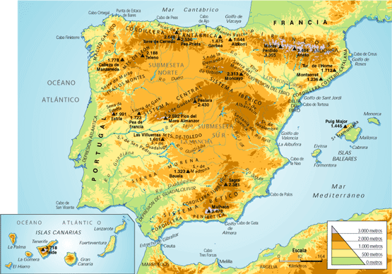
Mapa Físico de España
Aquí tenéis un mapa físico de España para que podáis estudiar en cualquier parte
jueves, 15 de septiembre de 2016
Lesson 1 (English version)
Unit 1 The
landforms of Spain
a) Spain´s main geographic features
- Spain
consists of a large part
of the Iberian Peninsula, The Canary Island and the Balearic Islands,
Ceuta and Melilla.
- Spain
is in the Northern hemisphere and shares a border with France and
Andorra (N), Portugal and the Atlantic Ocean (W), Cantabrian sea (NW),
Mediterranean Sea (E) and Africa (S).
- The
Balearic Islands are an archipielago in the Mediterranean Sea.
- The
Canary Islands are in the Atlantic Ocean (located 1000 km SW of the
peninsula) and it´s an archipielago too.
- Spain
has got a high average altitude because it has got numerous mountainous ranges and systems
through the country and the Canary Islands.
b) The
Meseta (Interiors)
- It´s
the plateau at the centre of the peninsula. It´s average altitude is 650
metres, the highest plateau in Europe.
- The
rivers in the meseta drain
their water into the Atlantic Ocean.
- The
Central System (SISTEMA CENTRAL): It divides the meseta into northern
sub-plateau (SUBMESETA NORTE) southern sub-plateau (SUBMESETA SUR). The
Central System is divided into three mountains: Somosierra, Guadarrama and
Gredos (which includes Almanzor).
- The
Toledo Mountains (MONTES DE TOLEDO): They separate the Tajo Valley and the Guadiana
Valley in the southern sub-plateau.
- The
Meseta´s Borders: They includes…
- The
Mountains of León: In the norwesthern part of the Meseta. They
separate C. y León from Galicia.
- The
Cantabrian Range separates Cantabria and Asturias from C. y León.
- The
Iberian System is in the mesetás eastern edge. It runs through
C. y León, Aragón, C. la Mancha and Valencia. It includes, Picos de Urbión
and the Albarracín Mountains.
- Sierra
Morena: It separates
the Meseta from the Guadalquivir Valley.
c) The mountain ranges outside the Meseta
There are four mountain ranges in
the north:
- The
Galician Massif: Low altitude mountains in the northwest part of the country.
- The
Basque Mountains: In the north
part it has got some altitudes (Aizkorri, 1528m)
- The
Pyrenees: They stretch
from the Cantabrian sea to the Mediterranean sea travelling across Navarra,
Aragón and Catalonia. They are the natural border between Spain and
France (Aneto 3404m)
- The
Catalan Coastal Range:
A low altitude mountain range parallel to the Mediterranean sea.
The Baetic System is in the southest part of Spain
and it´s divided into:
- The
Penibaetic Range: closer to the coast of the Mediterranean sea.
It contains Ronda Mountains, Baza
Mountains and Sierra Nevada ( Mulhacen 3478 m and Veleta 3396m).
- The
Subbaetic Range, in a further inlands. The most notable mountains
are The Cazorla Mountains and the Segura Mountains.
d) Depressions
outside the Meseta
A depression is a low flat área of land. There are
two main depressions in Spain:
- The
Ebro Depression: From west
to east through La Rioja, Navarra, Aragón and Catalonia. It averages 200
metres in altitude and it is made up different terrains. The Ebro
Delta is formed by the deposition of materials along the course of the
river and creates an area of land that enters the sea in the shape
of an arrow.
- The
Guadalquivir Depression:
It´s 600 km long, and it is a vaste triangular-shaped plain. It
is made up of clay deposits and form campiñas (rolling hills). It
averages 100 metres in altitude and in this Depression we can find Doñana
National Park.
Hola a todos chicos y chicas de 6º de primaria del colegio Liceo Cónsul. Al finalizar cada tema iremos colgando los apuntes tanto en español (para preparar mejor el examen final de 6º de la Comunidad de Madrid) como en Inglés (para repasar nuestra asignatura de Social Science.
Un saludo a todos y Feliz curso!!!!!!!!!!!!!!
Un saludo a todos y Feliz curso!!!!!!!!!!!!!!
Suscribirse a:
Comentarios (Atom)