Unit 1 The
landforms of Spain
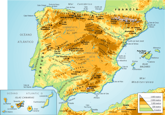
a) Spain´s main geographic features
- Spain
consists of a large part
of the Iberian Peninsula, The Canary Island and the Balearic Islands,
Ceuta and Melilla.
- Spain
is in the Northern hemisphere and shares a border with France and
Andorra (N), Portugal and the Atlantic Ocean (W), Cantabrian sea (NW),
Mediterranean Sea (E) and Africa (S).
- The
Balearic Islands are an archipielago in the Mediterranean Sea.
- The
Canary Islands are in the Atlantic Ocean (located 1000 km SW of the
peninsula) and it´s an archipielago too.
- Spain
has got a high average altitude because it has got numerous mountainous ranges and systems
through the country and the Canary Islands.
b) The
Meseta (Interiors)
- It´s
the plateau at the centre of the peninsula. It´s average altitude is 650
metres, the highest plateau in Europe.
- The
rivers in the meseta drain
their water into the Atlantic Ocean.
- The
Central System (SISTEMA CENTRAL): It divides the meseta into northern
sub-plateau (SUBMESETA NORTE) southern sub-plateau (SUBMESETA SUR). The
Central System is divided into three mountains: Somosierra, Guadarrama and
Gredos (which includes Almanzor).
- The
Toledo Mountains (MONTES DE TOLEDO): They separate the Tajo Valley and the Guadiana
Valley in the southern sub-plateau.
- The
Meseta´s Borders: They includes…
- The
Mountains of León: In the norwesthern part of the Meseta. They
separate C. y León from Galicia.
- The
Cantabrian Range separates Cantabria and Asturias from C. y León.
- The
Iberian System is in the mesetás eastern edge. It runs through
C. y León, Aragón, C. la Mancha and Valencia. It includes, Picos de Urbión
and the Albarracín Mountains.
- Sierra
Morena: It separates
the Meseta from the Guadalquivir Valley.
c) The mountain ranges outside the Meseta
There are four mountain ranges in
the north:
- The
Galician Massif: Low altitude mountains in the northwest part of the country.
- The
Basque Mountains: In the north
part it has got some altitudes (Aizkorri, 1528m)
- The
Pyrenees: They stretch
from the Cantabrian sea to the Mediterranean sea travelling across Navarra,
Aragón and Catalonia. They are the natural border between Spain and
France (Aneto 3404m)
- The
Catalan Coastal Range:
A low altitude mountain range parallel to the Mediterranean sea.
The Baetic System is in the southest part of Spain
and it´s divided into:
- The
Penibaetic Range: closer to the coast of the Mediterranean sea.
It contains Ronda Mountains, Baza
Mountains and Sierra Nevada ( Mulhacen 3478 m and Veleta 3396m).
- The
Subbaetic Range, in a further inlands. The most notable mountains
are The Cazorla Mountains and the Segura Mountains.
d) Depressions
outside the Meseta
A depression is a low flat área of land. There are
two main depressions in Spain:
- The
Ebro Depression: From west
to east through La Rioja, Navarra, Aragón and Catalonia. It averages 200
metres in altitude and it is made up different terrains. The Ebro
Delta is formed by the deposition of materials along the course of the
river and creates an area of land that enters the sea in the shape
of an arrow.
- The
Guadalquivir Depression:
It´s 600 km long, and it is a vaste triangular-shaped plain. It
is made up of clay deposits and form campiñas (rolling hills). It
averages 100 metres in altitude and in this Depression we can find Doñana
National Park.